In this article, Tracdiaso would like to share with you the basic information about map projection and geodetic coordinate system.
Mục lục
The concept of map projection
The ground is a curved surface, in order to represent it on the plane so accurately, with the least distortion, it is necessary to follow a certain mathematical rule called a map projection.
To perform a map projection, first project the natural ground to the datum (spherical or elliptical), and then convert from the datum to the plane. Depending on the geographical location of each country, suitable circular map projections can be applied, in this textbook only the concepts of some commonly used projections are presented.
Plane projection and conventional perpendicular coordinate system
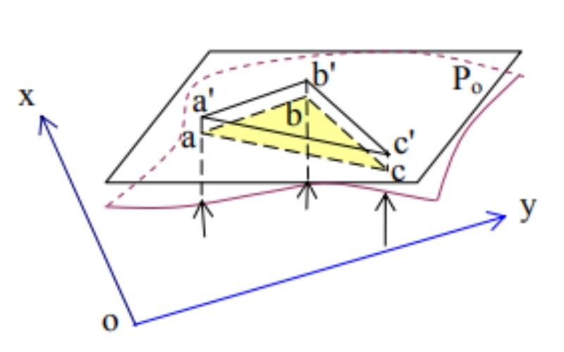
When the small measurement area has an area of less than 100 km2, the distortion error of the map projection is small, so it can be considered that the area is a plane and the rays projected from the center of the earth are parallel to each other.
If that area is located in remote places, far from the government control grid, it can be assumed that a coordinate system perpendicular to the OX axis is the magnetic north determined by the compass, the OY axis is perpendicular to the OX axis and the direction eastward; The origin is the intersection of the two axes and is selected to the southwest of that zone.
UTM projection and Vietnam National coordinate system VN-2000
UTM . projection
The map projection UTM (Universal Transverse Mercator) is a horizontal cylindrical projection at right angles and is implemented as follows:
- Divide the earth into 60 zones by the meridians 6o apart, numbered the zones from 1 to 60 starting from the prime meridian, counterclockwise and closing to the prime meridian.
- Construct a horizontal cylinder that intersects the earth’s sphere in two symmetrical curves through the mid-zone meridian and has a projection ratio k = 1 (no length distortion). The axial meridian outside the cylinder has a projection ratio k = 0.9996.
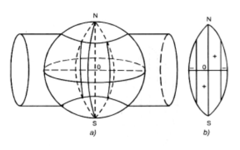
– Using the center of the earth as the projection center, project each zone on the cylinder in turn according to the principle of radial projection. After projection, expand the cylinder to a plane.
The UTM projection has the advantage that the distortion is evenly distributed and has a small value; on the other hand, now for the convenience of using the common coordinate system in the region and the world, Vietnam has used this projection grid in the VN-2000 national coordinate system instead of the Gauss-Kruger projection in the old coordinate system. HN-72.
UTM . plane perpendicular coordinate system
In the UTM projection, the projection zones all have axis meridians degenerate into vertical line selected as the OX axis; The equator degenerates into a horizontal line chosen as the OY axis, the OX line perpendicular to the OY forms the UTM plane perpendicular coordinate system on the projection zones.
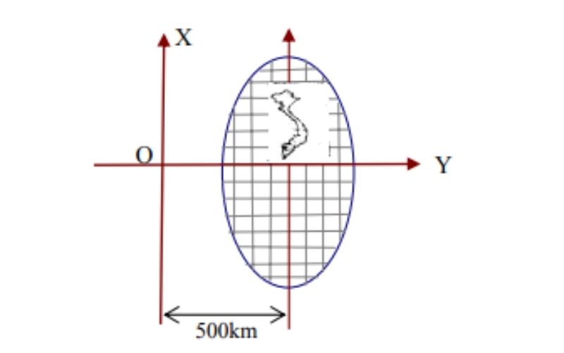
In order for the Y coordinate value to be non-negative, it is conventional to leave the OX axis to the west 500km and specify the Y coordinate with the ordinal number of the projection zone in front (X = 2524376,437; Y = 18.704865,453) . On topographic maps, for ease of use, lines have been drawn
Lines parallel to the OX and OY axes form a grid of coordinate squares. This UTM plane perpendicular coordinate system is used in the VN-2000 coordinate system.
Vietnam National Coordinate System VN-2000
The VN-2000 coordinate system was decided by the Prime Minister to be the national Geodetic and Map coordinate system of Vietnam and took effect on August 12, 2000. This coordinate system has the following characteristics:
– Using Ellipse WGS-84 (World Geodesic System 1984) as a practical Ellipse, Ellipse
This has semi-major axis a = 6378137, degree α = 1:298.2.
– Using projection and plane perpendicular coordinate system UTM.
– Original coordinates in the campus of the Institute of Cadastral Technology, Hoang Quoc Viet, Hanoi.
Giải pháp Trắc địa số toàn diệntại Tracdiaso.com
Hotline: 0917111392 - 0869191996
Địa chỉ: Tòa nhà D8, Đại học Bách Khoa Hà Nội, Trần Đại Nghĩa, Hà Nội, Việt Nam
Email: Vietflycam1102@gmail.com
Youtube: https://www.youtube.com/channel/UCgRFxKxd2vt5gn_mbS1sJgA