Topographic survey services by Flycam (UAV) and RTK meter are the optimal choice for professional surveying, surveying and mapping activities. It is an important step in construction investment such as a project on a farm, golf course, resort or a large-scale real estate project.
Mục lục
Why should you choose RTK topographic surveying services?
Are you investing in a farm project, golf course, resort or a large-scale real estate project?
Recording topographic surface data by traditional methods over a long period of time is very expensive, especially with project sizes up to hundreds of hectares.
Usually, projects are only interested in topographic data for the first time to calculate the leveling, serving the design work at the scale of 1/1000, 1/2000 and even 1/500…. Some projects require surface observation and development over a certain period of time.
At this time, topographic survey by Flycam is the best choice with:
- Cheaper cost
- Faster execution time
- Higher accuracy
You can recheck the terrain surface not only with an image, but also with a 3D model of the terrain.
On June 30, 2021, the Ministry of Natural Resources and Environment issued Circular 07/2021 / TT-BTNMT on “Technical regulations on acquisition and processing of digital image data from unmanned aircraft for construction, update national geographic database at 1:2,000 scale, 1:5,000 scale and establish topographic maps at 1:500, 1:1,000 scale.
Thus, in terms of legal corridor regulations, the method of topographic survey at scale 1/500, 1/1000 by Flycam has been recognized by state agencies.
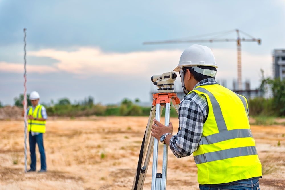
Advantages and disadvantages of surveying terrain by Flycam (UAV) and RTK
The application of UAV in topographic surveying in particular and mapping the current status in general brings a lot of benefits.
Advantages of surveying terrain by Flycam
Cost savings
According to the traditional topographic survey method, if the area is too large or can be divided much, the survey and measurement are very difficult. The cost of the survey has gone up a lot. With Drone RTK, those difficult cases will be solved and the cost will be much cheaper.
Survey progress is taking place quickly on a large scale
With current Drone RTK technology, the topographic survey on a large scale. It takes only 1-2 business days to complete the field work. While measuring topography 1/1000 on a large scale sometimes up to more than 30 days. For example, 300ha survey area, topographic measurement 1/1000 2 teams may take 20-30 working days.
Store all images to review when needed
Visual at the time of flight capture, it’s a valuable source of history for cross-checking during project inspections.
Accuracy comparable to traditional measuring technology
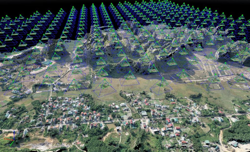
Collect a lot of survey data with high accuracy: Using drones can collect thousands of measurements expressed in various formats. Built-in GPS RTK devices ensure geospatial accuracy up to 3 cm.
Mapping inaccessible areas: An aerial mapping drone can take off and fly almost anywhere, unrestricted by hard-to-reach areas, steep air safety or harsh terrain
Limitations of RTK Drone measurement method in topographic surveying services
The application for permission to fly to take photos to create topographic maps now needs to follow exactly the procedures for applying for a flight permit. The unit that licensed the flight was the Operations Department – General Staff.
For unfamiliar terrain areas, the plane is easy to crash if the estimated altitude is wrong.
Besides, the current aircraft’s battery life is still weak. The flight time of an engine shift is only about 20-30 minutes. The design of the flight path needs experienced surveyors to optimize the flight path for the project.
Topographic survey service by Flycam (UAV) and RTK . meter
Geodetic number providing unmanned aircraft solutions: 3D scanning flight, digital surveying and mapping in a comprehensive way for cadastral work, design, leveling, planning approval, civil construction, heritage preservation… with high accuracy with a standardized software platform that can save you thousands of dollars.
2D-3D scanning with a drone
Create a 2D digital map of the scanned area
Create a 3D digital map of the scanned area
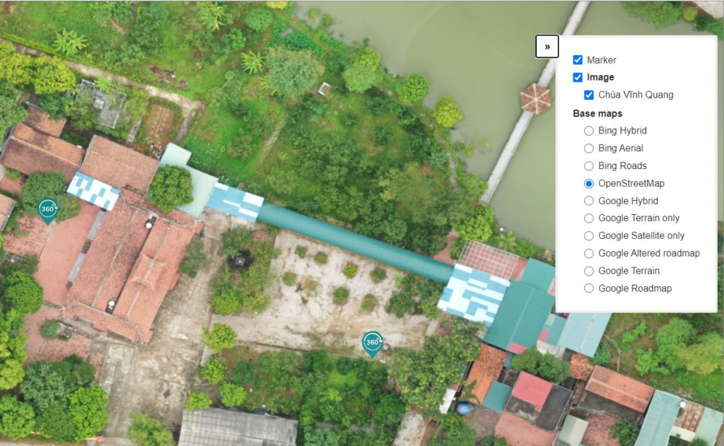
Topographic map editor 1/500, 1/2000, 1/5000
Processing image data in VR 360 Panaroma
Digital data storage and display platform
Conclude:
Topographic surveying service is carried out by a professional team with a modern unmanned aerial vehicle system. If you need advice on surveying and mapping services, please contact:
Phone number: 0917111392 – 0869191996
Email: Vietflycam1102@gmail.com
Website: https://vietflycam.vn
Youtube: http://www.youtube.com/c/VietFlycam
Giải pháp Trắc địa số toàn diệntại Tracdiaso.com
Hotline: 0917111392 - 0869191996
Địa chỉ: Tòa nhà D8, Đại học Bách Khoa Hà Nội, Trần Đại Nghĩa, Hà Nội, Việt Nam
Email: Vietflycam1102@gmail.com
Youtube: https://www.youtube.com/channel/UCgRFxKxd2vt5gn_mbS1sJgA